Main call: M0BEW. Special Contest Call: M4T.
Tim Elwell. DOB: 23.05.1973. Licensed since 1997.
Locator: IO82RJ. WAB: SO67. IOTA: EU-005
Shropshire, England. UK.
.jpg)

Force12 C3. 10m to 20m.
30m 1/4 Vertical
30m 1/4 Vertical
40m Dipole. 1/4 Vertical.
60m 1/4 Vertical.
80m Dipole. 1/4 Vertical.
160m Dipole.
80m Dipole. 1/4 Vertical.
160m Dipole.
RX Antennas. Beverages, NW NE.
VHF.
WSJT-X, MSHV, JTDX.
TS590SG x 2
TS590SG x 2
IC910H


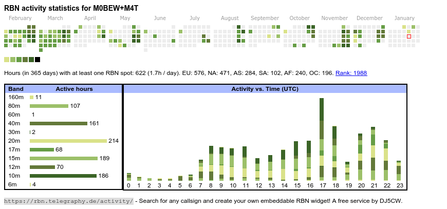
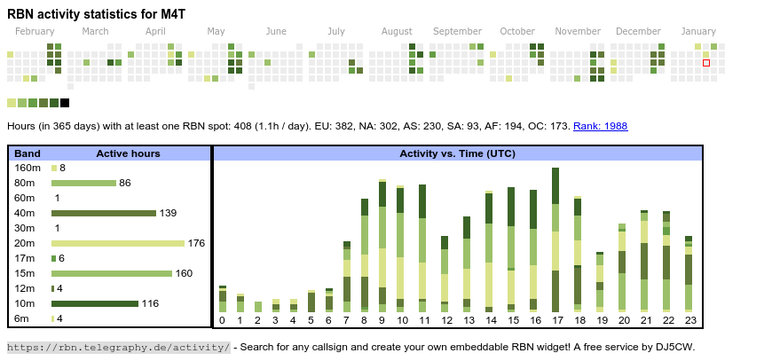
Log Data 22/08/2022. QSO total = 338,705.
DXCC, Grids, IOTA, USACA, DOK, WAB worked.
@ M0BEW QTH Shropshire, Clee Hill. IO82rj.
 Shropshire
is a county in the West Midlands of England, bordering Wales to the
west, Cheshire to the north, Staffordshire to the east, and
Worcestershire and Herefordshire to the south.
Shropshire
is a county in the West Midlands of England, bordering Wales to the
west, Cheshire to the north, Staffordshire to the east, and
Worcestershire and Herefordshire to the south.
The county's population and economy is centred on five towns: the county town of Shrewsbury, which is culturally and historically important and close to the centre of the county; Telford, a new town in the east which was constructed around a number of older towns, most notably Wellington, Dawley and Madeley, which is today the most populous; and Oswestry in the northwest, Bridgnorth just to the south of Telford, and Ludlow in the south. The county has many market towns, including Whitchurch in the north, Newport northeast of Telford and Market Drayton in the northeast of the county.
The Shropshire Hills Area of Outstanding Natural Beauty covers about a quarter of the county, mainly in the south. Shropshire is one of England's most rural and sparsely populated counties, with a population density of 136/km2 (350/sq mi).
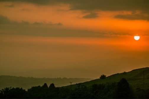
 The Clee Hills are a range of hills in Shropshire, England near Ludlow,
consisting of Brown Clee Hill 1,772 feet (540 m), the highest peak in
Shropshire, and Titterstone Clee Hill 1,749 feet (533 m).
The Clee Hills are a range of hills in Shropshire, England near Ludlow,
consisting of Brown Clee Hill 1,772 feet (540 m), the highest peak in
Shropshire, and Titterstone Clee Hill 1,749 feet (533 m).
The hills stretch over 15 miles and run north - south, and for about this distance the lowest point along the hills is just under 984 feet (300 m). Titterstone Clee Hill is around five miles south of Brown Clee Hill.
Views from the west of the hills spread as far as Snowdonia and Cadair Idris, the Brecon Beacons, the Black Mountains, The Long Mynd, Stiperstones Shropshire's third highest peak, Corndon Hill and Radnor Forest. To the south are the Malvern Hills and the Cotswolds, and to the east are the Clent Hills, Turner's Hill, Barr Beacon and the spread of the West Midlands. To the north is Cannock Chase, and on a very clear day the hills of the Peak District including The Roaches and Winter Hill.
It is possible to see the urban centres of Dudley and Wolverhampton. The hills mark a clear eastern boundary to the Shropshire Hills, and are just west of the Severn Valley between Bridgnorth and Bewdley. The hills stand out over the surrounding countryside and can be seen from well into Staffordshire, Worcestershire, Herefordshire and the Black Country. They can also be seen, on a clear day, from the M5 Motorway on the northbound approach to Bromsgrove. The hills were created by glacial activity in the last Ice Age.

Microham u2R
OM6BPF + 5B4AGN Bandpass filters
PA's

Updated. 01/01/22.
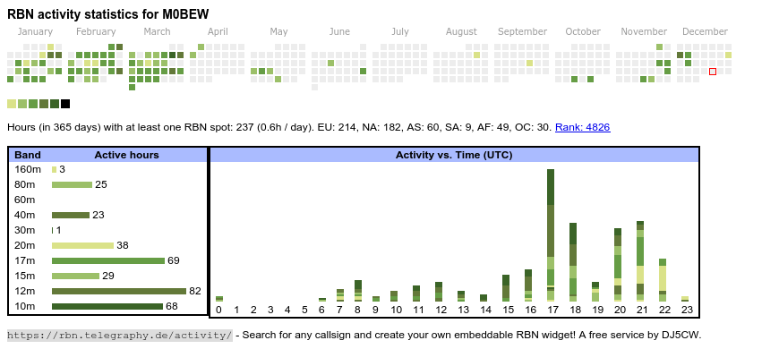
Log Data 22/08/2022. QSO total = 338,705.
DXCC, Grids, IOTA, USACA, DOK, WAB worked.
@ M0BEW QTH Shropshire, Clee Hill. IO82rj.
The county's population and economy is centred on five towns: the county town of Shrewsbury, which is culturally and historically important and close to the centre of the county; Telford, a new town in the east which was constructed around a number of older towns, most notably Wellington, Dawley and Madeley, which is today the most populous; and Oswestry in the northwest, Bridgnorth just to the south of Telford, and Ludlow in the south. The county has many market towns, including Whitchurch in the north, Newport northeast of Telford and Market Drayton in the northeast of the county.
The Shropshire Hills Area of Outstanding Natural Beauty covers about a quarter of the county, mainly in the south. Shropshire is one of England's most rural and sparsely populated counties, with a population density of 136/km2 (350/sq mi).

The hills stretch over 15 miles and run north - south, and for about this distance the lowest point along the hills is just under 984 feet (300 m). Titterstone Clee Hill is around five miles south of Brown Clee Hill.
Views from the west of the hills spread as far as Snowdonia and Cadair Idris, the Brecon Beacons, the Black Mountains, The Long Mynd, Stiperstones Shropshire's third highest peak, Corndon Hill and Radnor Forest. To the south are the Malvern Hills and the Cotswolds, and to the east are the Clent Hills, Turner's Hill, Barr Beacon and the spread of the West Midlands. To the north is Cannock Chase, and on a very clear day the hills of the Peak District including The Roaches and Winter Hill.
It is possible to see the urban centres of Dudley and Wolverhampton. The hills mark a clear eastern boundary to the Shropshire Hills, and are just west of the Severn Valley between Bridgnorth and Bewdley. The hills stand out over the surrounding countryside and can be seen from well into Staffordshire, Worcestershire, Herefordshire and the Black Country. They can also be seen, on a clear day, from the M5 Motorway on the northbound approach to Bromsgrove. The hills were created by glacial activity in the last Ice Age.
South Shropshire is more rural, with fewer settlements and no large
towns, and its landscape differs greatly from that of North Shropshire.
The area is dominated by significant hill ranges and river valleys,
woods, pine forests and "batches", a colloquial term for small valleys
and other natural features. Farming is more pastoral than the arable
found in the north of the county. The only substantial towns are Bridgnorth, with a population of around 12,000 people, Ludlow and Church Stretton. The Shropshire Hills AONB is located in the south-west, covering an area of 810 km2 (312 sq mi); it forms the only specifically protected area of the county. Inside this area is the popular Long Mynd, a large plateau of 516 m (1,693 ft) and Stiperstones 536 metres (1,759 ft) high to the East of the Long Mynd, overlooking Church Stretton.

The skyline of Ludlow, one of south Shropshire's market towns, dominated by its sizeable castle and church.
Tim M0BEW. M4T.
Marvellous "shire-land" ...
ReplyDelete